Discussions All (12) Open (11)

  • A secondary stopbank extending from the terrace on Mount Thomas Road to the east of the racecourse

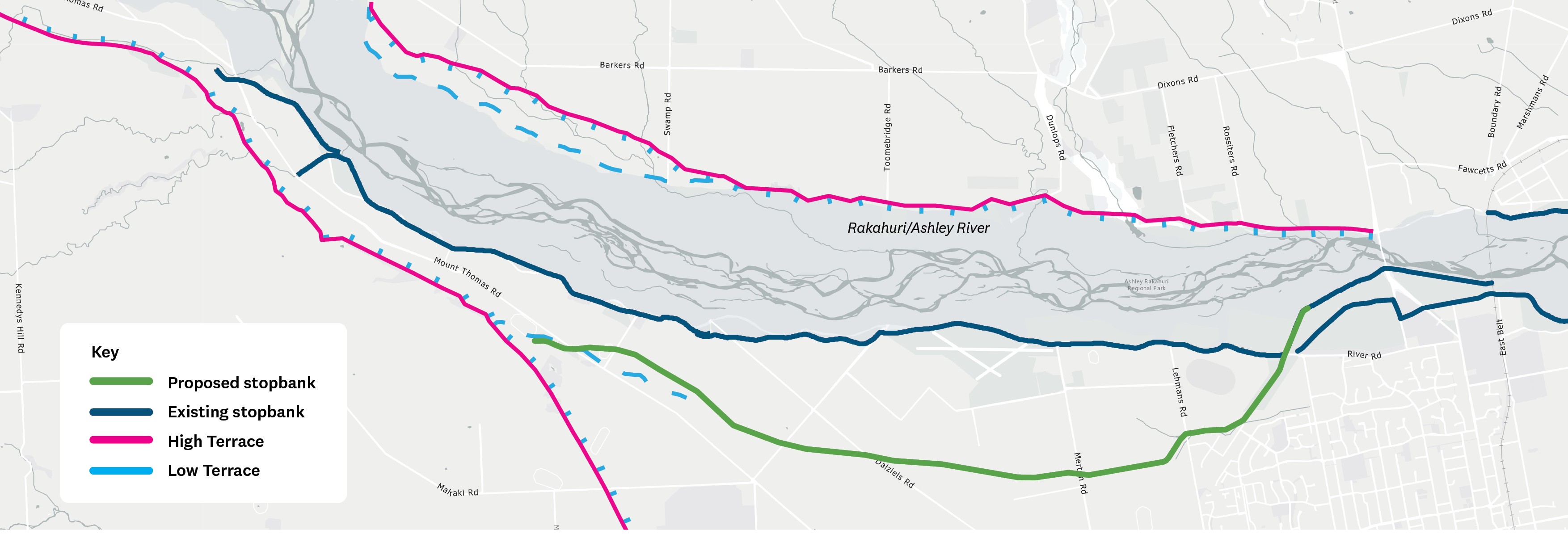
    This option would see us building a second stopbank further south of the river, starting at the terrace on Mount Thomas Road and connecting back to the primary stopbank just east of the racecourse.Option A: A secondary stopbank extending from the terrace on Mount Thomas Road to the east of the racecourse

    Pros

    • This provides two levels of protection for the urban areas of Rangiora and Kaiapoi, as well as the rural areas that are currently within the modelled flow paths for breakouts between the Ōkūkū to Rangiora

    Cons

    • This is the longest alignment

    • The option crosses a significant number of properties

    • This option wouldn’t improve flood protection for properties in between the primary and secondary stopbanks, and would increase flood depths for some of these properties


    Note the options included here are for the part of the river that extends from the Ōkūkū confluence to Rangiora Railway Bridge. We will share design options for downstream areas later in 2026. You can add comments directly to these options or give your feedback via the give feedback section of the page.

    Please note that comments you make in this section will appear publicly, so please protect your personal privacy and the privacy of others. Do not share personable or confidential information in this section. 

    Please remain polite and respectful of others and their opinions. We may remove content that contains: Racism or hate speech, disrespectful, rude, or abusive language, threats to another person or organisation, including us and our employees, potentially defamatory statements, spam or links to external sites, off-topic information irrelevant to the thread, obscene, offensive, harassing, or discriminatory content toward any person or organisation, including us and our employees.


    A secondary stopbank extending from the terrace on Mount Thomas Road to the east of the racecourse

    This option would see us building a second stopbank further south of the river, starting at the terrace on Mount Thomas Road and connecting back to the primary stopbank just east of the racecourse.Option A: A secondary stopbank extending from the terrace on Mount Thomas Road to the east of the racecourse

    Pros

    • This provides two levels of protection for the urban areas of Rangiora and Kaiapoi, as well as the rural areas that are currently within the modelled flow paths for breakouts between the Ōkūkū to Rangiora

    Cons

    • This is the longest alignment

    • The option crosses a significant number of properties

    • This option wouldn’t improve flood protection for properties in between the primary and secondary stopbanks, and would increase flood depths for some of these properties


    Note the options included here are for the part of the river that extends from the Ōkūkū confluence to Rangiora Railway Bridge. We will share design options for downstream areas later in 2026. You can add comments directly to these options or give your feedback via the give feedback section of the page.

    Please note that comments you make in this section will appear publicly, so please protect your personal privacy and the privacy of others. Do not share personable or confidential information in this section. 

    Please remain polite and respectful of others and their opinions. We may remove content that contains: Racism or hate speech, disrespectful, rude, or abusive language, threats to another person or organisation, including us and our employees, potentially defamatory statements, spam or links to external sites, off-topic information irrelevant to the thread, obscene, offensive, harassing, or discriminatory content toward any person or organisation, including us and our employees.

    You can use @ to tag somebody in the conversation

    Reply notification settings
    Email
    loader image
    Didn't receive confirmation?
    Seems like you are already registered, please provide the password. Forgot your password? Create a new one now.
    Submitting your comment
    Cancel
  • A secondary stopbank from the terrace opposite Groyne 8 to the east of the airfield 

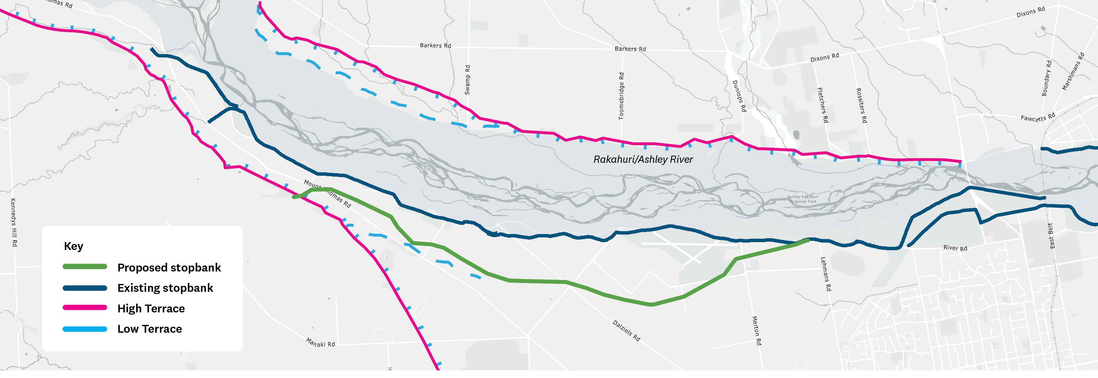
    This option would involve building a second stopbank further south of the river, starting around Groyne 8 and connecting back to the primary stopbank just east of the airfield.

    Option B: A secondary stopbank from the terrace opposite Groyne 8 to the east of the airfield


    Pros

    • This would maximise the length of secondary stopbank protection
    • This option would provide increased flood protection for more people living on the south of the stopbank

    Cons

    • This option would have implications for potential land development south of the airfield
    • Constriction of breakout flow where the proposed bank first crosses Mount Thomas Road, requiring mitigation for high water velocities

    Note the options included here are for the part of the river that extends from the Ōkūkū confluence to Rangiora Railway Bridge. We will share design options for downstream areas later in 2026. You can add comments directly to these options or give your feedback via the give feedback section of the page.

    Please note that comments you make in this section will appear publicly, so please protect your personal privacy and the privacy of others. Do not share personable or confidential information in this section. 

    Please remain polite and respectful of others and their opinions. We may remove content that contains: Racism or hate speech, disrespectful, rude, or abusive language, threats to another person or organisation, including us and our employees, potentially defamatory statements, spam or links to external sites, off-topic information irrelevant to the thread, obscene, offensive, harassing, or discriminatory content toward any person or organisation, including us and our employees.

    A secondary stopbank from the terrace opposite Groyne 8 to the east of the airfield 

    This option would involve building a second stopbank further south of the river, starting around Groyne 8 and connecting back to the primary stopbank just east of the airfield.


    Option B: A secondary stopbank from the terrace opposite Groyne 8 to the east of the airfield


    Pros

    • This would maximise the length of secondary stopbank protection
    • This option would provide increased flood protection for more people living on the south of the stopbank

    Cons

    • This option would have implications for potential land development south of the airfield
    • Constriction of breakout flow where the proposed bank first crosses Mount Thomas Road, requiring mitigation for high water velocities

    Note the options included here are for the part of the river that extends from the Ōkūkū confluence to Rangiora Railway Bridge. We will share design options for downstream areas later in 2026. You can add comments directly to these options or give your feedback via the give feedback section of the page.

    Please note that comments you make in this section will appear publicly, so please protect your personal privacy and the privacy of others. Do not share personable or confidential information in this section. 

    Please remain polite and respectful of others and their opinions. We may remove content that contains: Racism or hate speech, disrespectful, rude, or abusive language, threats to another person or organisation, including us and our employees, potentially defamatory statements, spam or links to external sites, off-topic information irrelevant to the thread, obscene, offensive, harassing, or discriminatory content toward any person or organisation, including us and our employees.

    You can use @ to tag somebody in the conversation

    Reply notification settings
    Email
    loader image
    Didn't receive confirmation?
    Seems like you are already registered, please provide the password. Forgot your password? Create a new one now.
    Submitting your comment
    Cancel
  • A secondary stopbank starting at the low terrace across Mount Thomas Road from Groyne 7 to the east of the airfield

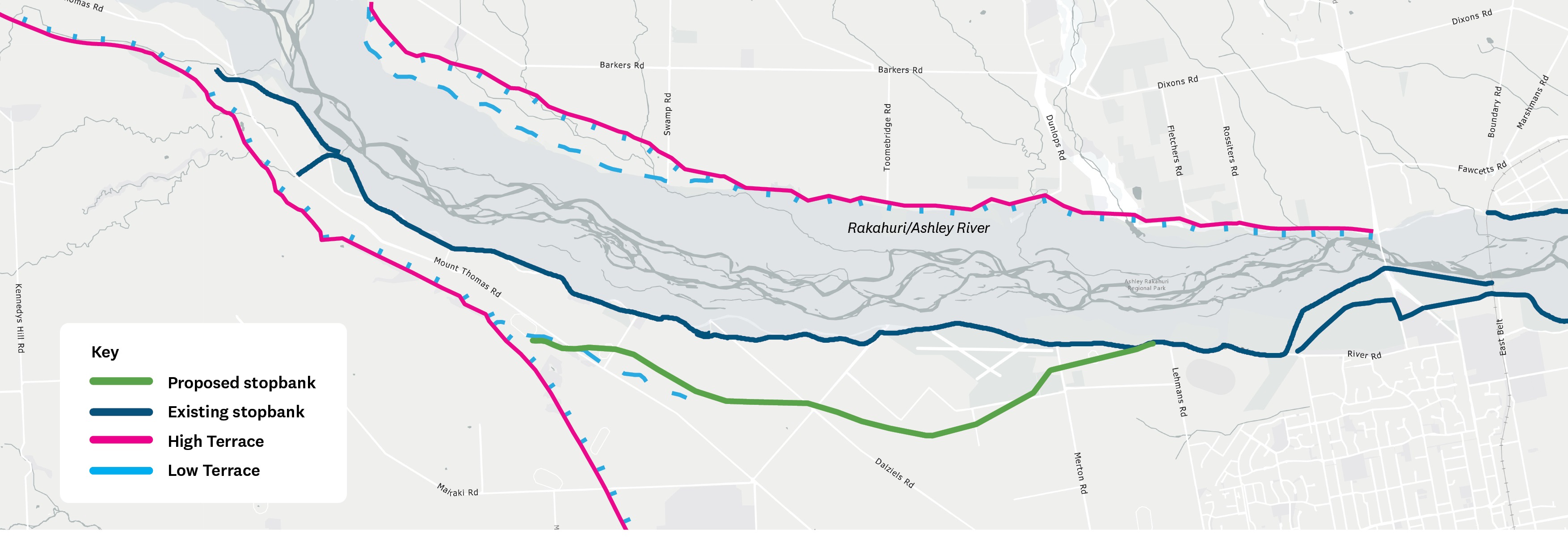
    This option would see us building a second stopbank south of the river, starting south of Groyne 7 and connecting back to the primary stopbank just east of the airfield.
    Option C: A secondary stopbank starting at the low terrace across Mount Thomas Road from Groyne 7 to the east of the airfield

    Pros

    • As with option B, this option would maximise the length of secondary stopbank protection, meaning:
      • It would provide increased flood protection for people living on the south of the stopbank
      • This has the benefit of incorporating more natural terrain features into the design, which will minimise earthworks when we come to construction

    Cons

    • This option would have implications for potential land development south of the airfield
    • Many dwellings within existing breakout flow towards the west of the river (the Ōkūkū confluence) would not get additional protection


    Note the options included here are for the part of the river that extends from the Ōkūkū confluence to Rangiora Railway Bridge. We will share design options for downstream areas later in 2026. You can add comments directly to these options or give your feedback via the give feedback section of the page.

    Please note that comments you make in this section will appear publicly, so please protect your personal privacy and the privacy of others. Do not share personable or confidential information in this section. 

    Please remain polite and respectful of others and their opinions. We may remove content that contains: Racism or hate speech, disrespectful, rude, or abusive language, threats to another person or organisation, including us and our employees, potentially defamatory statements, spam or links to external sites, off-topic information irrelevant to the thread, obscene, offensive, harassing, or discriminatory content toward any person or organisation, including us and our employees.

    A secondary stopbank starting at the low terrace across Mount Thomas Road from Groyne 7 to the east of the airfield

    This option would see us building a second stopbank south of the river, starting south of Groyne 7 and connecting back to the primary stopbank just east of the airfield.

    Option C: A secondary stopbank starting at the low terrace across Mount Thomas Road from Groyne 7 to the east of the airfield

    Pros

    • As with option B, this option would maximise the length of secondary stopbank protection, meaning:
      • It would provide increased flood protection for people living on the south of the stopbank
      • This has the benefit of incorporating more natural terrain features into the design, which will minimise earthworks when we come to construction

    Cons

    • This option would have implications for potential land development south of the airfield
    • Many dwellings within existing breakout flow towards the west of the river (the Ōkūkū confluence) would not get additional protection


    Note the options included here are for the part of the river that extends from the Ōkūkū confluence to Rangiora Railway Bridge. We will share design options for downstream areas later in 2026. You can add comments directly to these options or give your feedback via the give feedback section of the page.

    Please note that comments you make in this section will appear publicly, so please protect your personal privacy and the privacy of others. Do not share personable or confidential information in this section. 

    Please remain polite and respectful of others and their opinions. We may remove content that contains: Racism or hate speech, disrespectful, rude, or abusive language, threats to another person or organisation, including us and our employees, potentially defamatory statements, spam or links to external sites, off-topic information irrelevant to the thread, obscene, offensive, harassing, or discriminatory content toward any person or organisation, including us and our employees.

    You can use @ to tag somebody in the conversation

    Reply notification settings
    Email
    loader image
    Didn't receive confirmation?
    Seems like you are already registered, please provide the password. Forgot your password? Create a new one now.
    Submitting your comment
    Cancel
  • A series of shorter secondary stopbanks upstream of Groyne 7

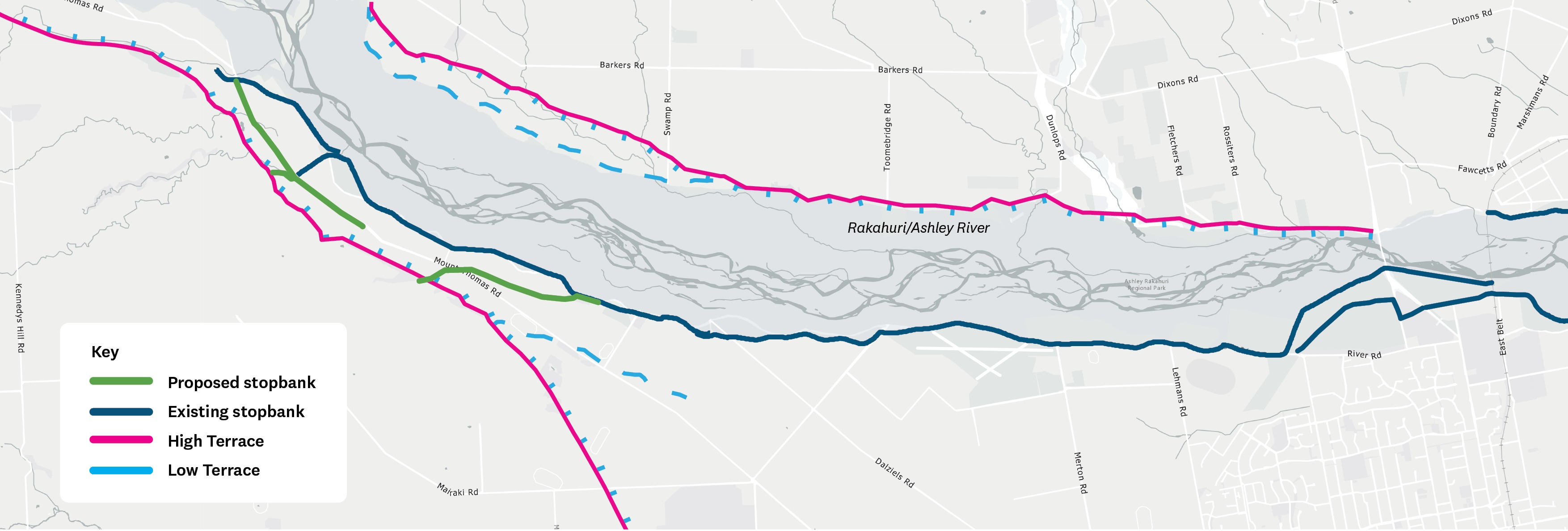
    This option would see us build a short secondary stopbank from the confluence of the Ōkūkū River, which returns the breakout flow around Groyne 7.
    Option D: A series of shorter secondary stopbanks upstream of Groyne 7


    Pros

    • This is the shortest option, which minimises impact on people living in the area in relation to impact on land and construction
    • It focuses on the high-risk section where two rivers meet
    • It could be a standalone option, or used in conjunction with the other options

    Cons

    • It doesn’t address the risk of the primary stopbank failing further downstream
    • Its efficacy would rely on extensive primary stopbank upgrades (these may be implemented anyway)

    Note the options included here are for the part of the river that extends from the Ōkūkū confluence to Rangiora Railway Bridge. We will share design options for downstream areas later in 2026. You can add comments directly to these options or give your feedback via the give feedback section of the page.

    Please note that comments you make in this section will appear publicly, so please protect your personal privacy and the privacy of others. Do not share personable or confidential information in this section. 

    Please remain polite and respectful of others and their opinions. We may remove content that contains: Racism or hate speech, disrespectful, rude, or abusive language, threats to another person or organisation, including us and our employees, potentially defamatory statements, spam or links to external sites, off-topic information irrelevant to the thread, obscene, offensive, harassing, or discriminatory content toward any person or organisation, including us and our employees.

    A series of shorter secondary stopbanks upstream of Groyne 7

    This option would see us build a short secondary stopbank from the confluence of the Ōkūkū River, which returns the breakout flow around Groyne 7.

    Option D: A series of shorter secondary stopbanks upstream of Groyne 7


    Pros

    • This is the shortest option, which minimises impact on people living in the area in relation to impact on land and construction
    • It focuses on the high-risk section where two rivers meet
    • It could be a standalone option, or used in conjunction with the other options

    Cons

    • It doesn’t address the risk of the primary stopbank failing further downstream
    • Its efficacy would rely on extensive primary stopbank upgrades (these may be implemented anyway)

    Note the options included here are for the part of the river that extends from the Ōkūkū confluence to Rangiora Railway Bridge. We will share design options for downstream areas later in 2026. You can add comments directly to these options or give your feedback via the give feedback section of the page.

    Please note that comments you make in this section will appear publicly, so please protect your personal privacy and the privacy of others. Do not share personable or confidential information in this section. 

    Please remain polite and respectful of others and their opinions. We may remove content that contains: Racism or hate speech, disrespectful, rude, or abusive language, threats to another person or organisation, including us and our employees, potentially defamatory statements, spam or links to external sites, off-topic information irrelevant to the thread, obscene, offensive, harassing, or discriminatory content toward any person or organisation, including us and our employees.

    You can use @ to tag somebody in the conversation

    Reply notification settings
    Email
    loader image
    Didn't receive confirmation?
    Seems like you are already registered, please provide the password. Forgot your password? Create a new one now.
    Submitting your comment
    Cancel
  • A secondary stopbank starting at the low terrace across Mount Thomas Road from Groyne 7 and joining the primary stopbank west of the airfield

    This option would see us constructing a secondary stopbank starting at the low terrace on Mount Thomas Road and joining the primary stopbank along Priors Road, to the west of the airfield.
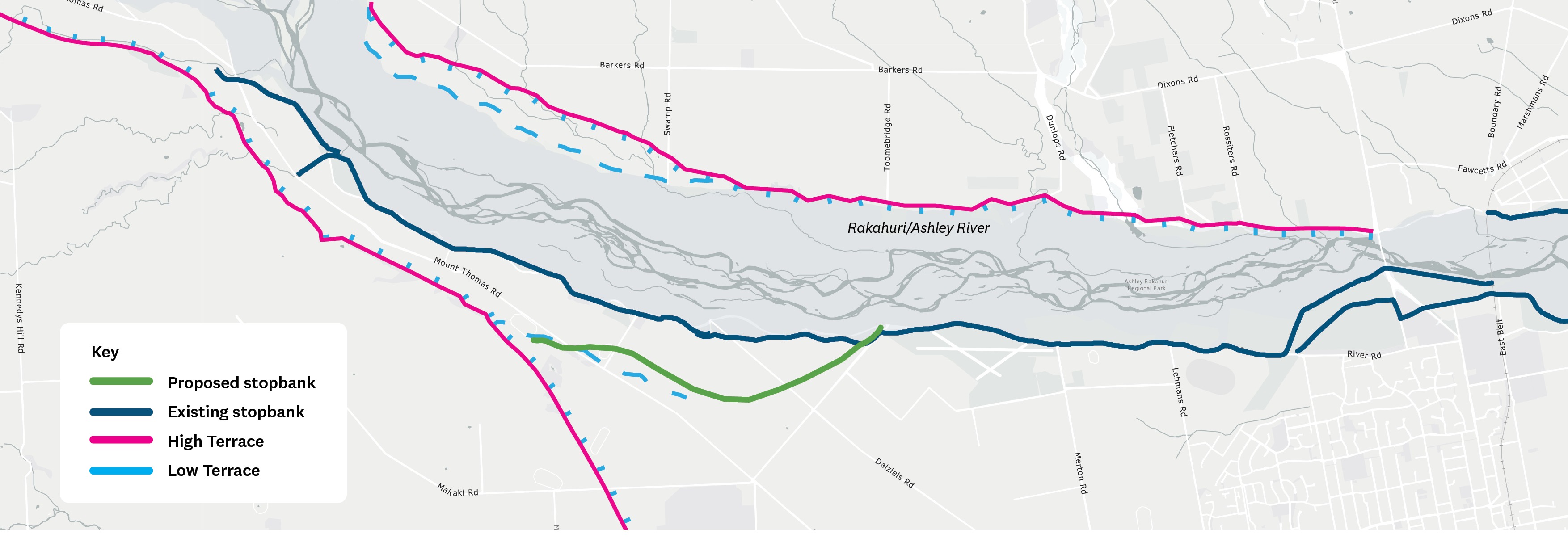
    Option E: A secondary stopbank starting at the low terrace across Mount Thomas Road from Groyne 7 and joining the primary stopbank west of the airfield Pros

    • This is a shorter alignment
    • It reduces the impact of land use and construction impact on neighbouring properties

    Cons

    • If the primary stopbank failed, there would be no additional protection between the airfield and Cones Road
    • Requires extensive upgrades to primary stopbank from airfield to Cones Road


    Note the options included here are for the part of the river that extends from the Ōkūkū confluence to Rangiora Railway Bridge. We will share design options for downstream areas later in 2026. You can add comments directly to these options or give your feedback via the give feedback section of the page.


    Please note that comments you make in this section will appear publicly, so please protect your personal privacy and the privacy of others. Do not share personable or confidential information in this section. 

    Please remain polite and respectful of others and their opinions. We may remove content that contains: Racism or hate speech, disrespectful, rude, or abusive language, threats to another person or organisation, including us and our employees, potentially defamatory statements, spam or links to external sites, off-topic information irrelevant to the thread, obscene, offensive, harassing, or discriminatory content toward any person or organisation, including us and our employees.

    A secondary stopbank starting at the low terrace across Mount Thomas Road from Groyne 7 and joining the primary stopbank west of the airfield

    This option would see us constructing a secondary stopbank starting at the low terrace on Mount Thomas Road and joining the primary stopbank along Priors Road, to the west of the airfield.

    Option E: A secondary stopbank starting at the low terrace across Mount Thomas Road from Groyne 7 and joining the primary stopbank west of the airfield Pros

    • This is a shorter alignment
    • It reduces the impact of land use and construction impact on neighbouring properties

    Cons

    • If the primary stopbank failed, there would be no additional protection between the airfield and Cones Road
    • Requires extensive upgrades to primary stopbank from airfield to Cones Road


    Note the options included here are for the part of the river that extends from the Ōkūkū confluence to Rangiora Railway Bridge. We will share design options for downstream areas later in 2026. You can add comments directly to these options or give your feedback via the give feedback section of the page.


    Please note that comments you make in this section will appear publicly, so please protect your personal privacy and the privacy of others. Do not share personable or confidential information in this section. 

    Please remain polite and respectful of others and their opinions. We may remove content that contains: Racism or hate speech, disrespectful, rude, or abusive language, threats to another person or organisation, including us and our employees, potentially defamatory statements, spam or links to external sites, off-topic information irrelevant to the thread, obscene, offensive, harassing, or discriminatory content toward any person or organisation, including us and our employees.

    You can use @ to tag somebody in the conversation

    Reply notification settings
    Email
    loader image
    Didn't receive confirmation?
    Seems like you are already registered, please provide the password. Forgot your password? Create a new one now.
    Submitting your comment
    Cancel
  • Upgrading the existing stopbank network

    This option considers upgrading the existing stopbanks, keeping the existing alignment the same (likely with a wider footprint), and increasing the height. Engineered erosion protection and strengthening measures such as rock protection and groynes would be required to increase resilience.
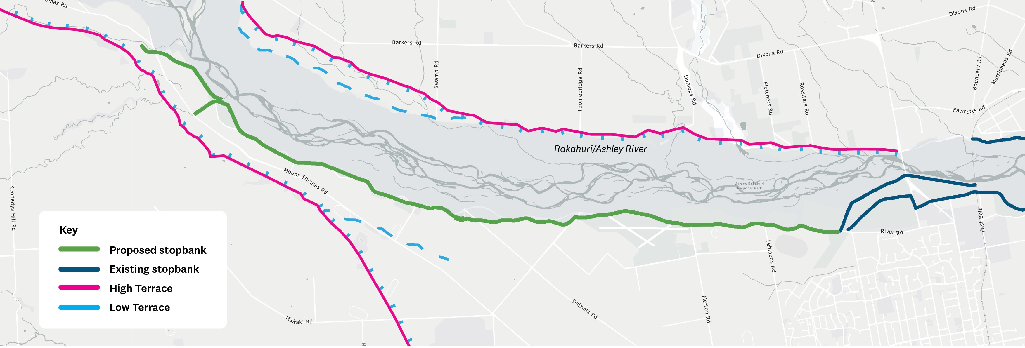

    Option F: Upgrading the existing stopbank network

    Pros

    • This option minimises impact to private property as it follows the existing alignment
    • Stopbank upgrades are likely to be required in some sections regardless of any alternative option selected
    • Minimal impact on proposed developments and existing activities

    Cons

    • No backup protection if floodwaters overtop or erode the stopbank
    • A higher stopbank allows the river to carry more water, which means better protection in most circumstances but potentially greater impacts for nearby properties if the stopbank is damaged during an extreme flood
    • Extent of strengthening could be significant as erosion can occur anywhere along the stopbank system

    Note the options included here are for the part of the river that extends from the Ōkūkū confluence to Rangiora Railway Bridge. We will share design options for downstream areas later in 2026. You can add comments directly to these options or give your feedback via the give feedback section of the page.

    Please note that comments you make in this section will appear publicly, so please protect your personal privacy and the privacy of others. Do not share personable or confidential information in this section. 

    Please remain polite and respectful of others and their opinions. We may remove content that contains: Racism or hate speech, disrespectful, rude, or abusive language, threats to another person or organisation, including us and our employees, potentially defamatory statements, spam or links to external sites, off-topic information irrelevant to the thread, obscene, offensive, harassing, or discriminatory content toward any person or organisation, including us and our employees.

    Upgrading the existing stopbank network

    This option considers upgrading the existing stopbanks, keeping the existing alignment the same (likely with a wider footprint), and increasing the height. Engineered erosion protection and strengthening measures such as rock protection and groynes would be required to increase resilience.


    Option F: Upgrading the existing stopbank network

    Pros

    • This option minimises impact to private property as it follows the existing alignment
    • Stopbank upgrades are likely to be required in some sections regardless of any alternative option selected
    • Minimal impact on proposed developments and existing activities

    Cons

    • No backup protection if floodwaters overtop or erode the stopbank
    • A higher stopbank allows the river to carry more water, which means better protection in most circumstances but potentially greater impacts for nearby properties if the stopbank is damaged during an extreme flood
    • Extent of strengthening could be significant as erosion can occur anywhere along the stopbank system

    Note the options included here are for the part of the river that extends from the Ōkūkū confluence to Rangiora Railway Bridge. We will share design options for downstream areas later in 2026. You can add comments directly to these options or give your feedback via the give feedback section of the page.

    Please note that comments you make in this section will appear publicly, so please protect your personal privacy and the privacy of others. Do not share personable or confidential information in this section. 

    Please remain polite and respectful of others and their opinions. We may remove content that contains: Racism or hate speech, disrespectful, rude, or abusive language, threats to another person or organisation, including us and our employees, potentially defamatory statements, spam or links to external sites, off-topic information irrelevant to the thread, obscene, offensive, harassing, or discriminatory content toward any person or organisation, including us and our employees.

    You can use @ to tag somebody in the conversation

    Reply notification settings
    Email
    loader image
    Didn't receive confirmation?
    Seems like you are already registered, please provide the password. Forgot your password? Create a new one now.
    Submitting your comment
    Cancel
  • Primary stopbank upgrades: upgrading existing stopbanks where required
    As with Reach 1, this option proposes raising and strengthening existing stopbanks where required to increase the level of flood protection provided. A geotechnical engineering consultant is investigating how and where this is possible. 
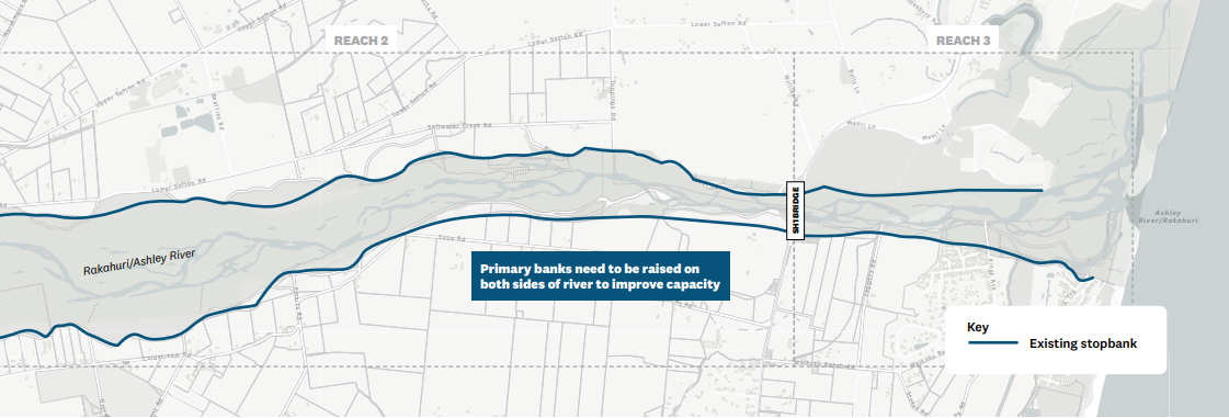
    Option F (Reach 2&3): Primary stopbank upgrades

    Pros

    • Minimises impacts on private land

    Cons

    • Doesn't address flow restrictions at the SH1 bridge, so a spillway may still be required.
    • May not be feasible to upgrade all sections of stopbank..


    Note: You can add comments directly to these options or give your feedback via the give feedback section of the page.

    Please note that comments you make in this section will appear publicly, so please protect your personal privacy and the privacy of others. Do not share personable or confidential information in this section. 

    Please remain polite and respectful of others and their opinions. We may remove content that contains: Racism or hate speech, disrespectful, rude, or abusive language, threats to another person or organisation, including us and our employees, potentially defamatory statements, spam or links to external sites, off-topic information irrelevant to the thread, obscene, offensive, harassing, or discriminatory content toward any person or organisation, including us and our employees.


    Primary stopbank upgrades: upgrading existing stopbanks where required
    As with Reach 1, this option proposes raising and strengthening existing stopbanks where required to increase the level of flood protection provided. A geotechnical engineering consultant is investigating how and where this is possible. 

    Option F (Reach 2&3): Primary stopbank upgrades

    Pros

    • Minimises impacts on private land

    Cons

    • Doesn't address flow restrictions at the SH1 bridge, so a spillway may still be required.
    • May not be feasible to upgrade all sections of stopbank..


    Note: You can add comments directly to these options or give your feedback via the give feedback section of the page.

    Please note that comments you make in this section will appear publicly, so please protect your personal privacy and the privacy of others. Do not share personable or confidential information in this section. 

    Please remain polite and respectful of others and their opinions. We may remove content that contains: Racism or hate speech, disrespectful, rude, or abusive language, threats to another person or organisation, including us and our employees, potentially defamatory statements, spam or links to external sites, off-topic information irrelevant to the thread, obscene, offensive, harassing, or discriminatory content toward any person or organisation, including us and our employees.


    You can use @ to tag somebody in the conversation

    Reply notification settings
    Email
    loader image
    Didn't receive confirmation?
    Seems like you are already registered, please provide the password. Forgot your password? Create a new one now.
    Submitting your comment
    Cancel
  • Stopbank retreat on Environment Canterbury-owned land


    This option proposes building a new stopbank on Environment Canterbury-owned land on the north side of the river and, once established, lowering or removing sections of the existing stopbank.

    For both Option G1 and Option G2, new flood protection vegetation would be planted and allowed to establish before the existing stopbank is lowered or removed. 
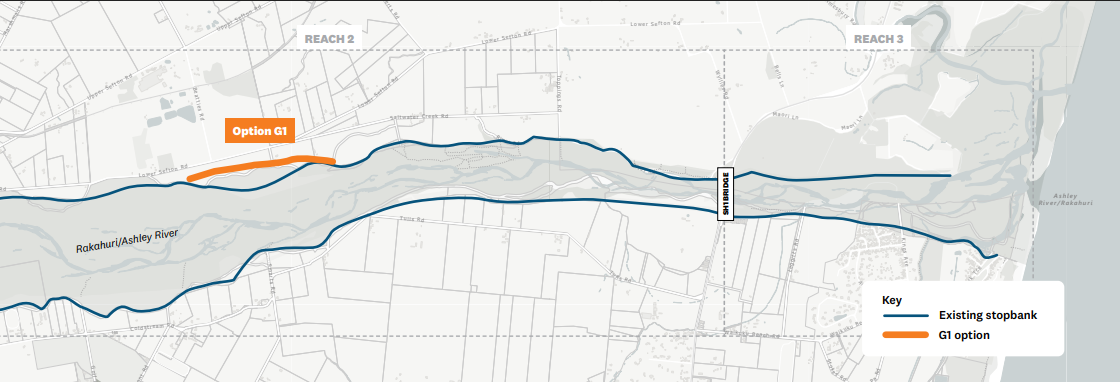
    Option G1: Stopbank retreat on Environment Canterbury  


    Pros

    • Increases flood-carrying capacity in this section.
    • Reduces constriction created by the existing stopbank alignment.
    • Primarily uses Environment Canterbury-owned land.

    Cons

    • Will take time for new flood protection vegetation to establish.
    • Addresses capacity issues over a relatively short section of the scheme (1.2 km).


    Note: You can add comments directly to these options or give your feedback via the give feedback section of the page.

    Please note that comments you make in this section will appear publicly, so please protect your personal privacy and the privacy of others. Do not share personable or confidential information in this section. 

    Please remain polite and respectful of others and their opinions. We may remove content that contains: Racism or hate speech, disrespectful, rude, or abusive language, threats to another person or organisation, including us and our employees, potentially defamatory statements, spam or links to external sites, off-topic information irrelevant to the thread, obscene, offensive, harassing, or discriminatory content toward any person or organisation, including us and our employees.

    Stopbank retreat on Environment Canterbury-owned land


    This option proposes building a new stopbank on Environment Canterbury-owned land on the north side of the river and, once established, lowering or removing sections of the existing stopbank.

    For both Option G1 and Option G2, new flood protection vegetation would be planted and allowed to establish before the existing stopbank is lowered or removed. 

    Option G1: Stopbank retreat on Environment Canterbury  


    Pros

    • Increases flood-carrying capacity in this section.
    • Reduces constriction created by the existing stopbank alignment.
    • Primarily uses Environment Canterbury-owned land.

    Cons

    • Will take time for new flood protection vegetation to establish.
    • Addresses capacity issues over a relatively short section of the scheme (1.2 km).


    Note: You can add comments directly to these options or give your feedback via the give feedback section of the page.

    Please note that comments you make in this section will appear publicly, so please protect your personal privacy and the privacy of others. Do not share personable or confidential information in this section. 

    Please remain polite and respectful of others and their opinions. We may remove content that contains: Racism or hate speech, disrespectful, rude, or abusive language, threats to another person or organisation, including us and our employees, potentially defamatory statements, spam or links to external sites, off-topic information irrelevant to the thread, obscene, offensive, harassing, or discriminatory content toward any person or organisation, including us and our employees.

    You can use @ to tag somebody in the conversation

    Reply notification settings
    Email
    loader image
    Didn't receive confirmation?
    Seems like you are already registered, please provide the password. Forgot your password? Create a new one now.
    Submitting your comment
    Cancel
  • Extended Stopbank Retreat: Stopbank retreat on Environment Canterbury and privately owned land. 

    This option builds on Option G1 by extending the proposed stopbank alignment along the edge of an old river terrace through privately owned land. For both Option G1 and Option G2, new flood protection vegetation would be planted and allowed to establish before the existing stopbank is lowered or removed. This staged approach helps maintain flood resilience during the transition.

    • Note: We will publish the map/s for Option G2 following further discussion with relevant landowners.     

    Pros

    • Increases flood-carrying capacity in this section of the river.
    • Reduces constriction created by the existing stopbank alignment.
    • Creates a wider flood corridor, allowing floodwaters to move more freely during large flood events.
    • Provides greater room for the river to operate naturally.
    • Supports long-term flood resilience by moving flood protection further from the river.
    • Enables establishment of new flood protection vegetation before the existing stopbank is lowered or removed.
    • May provide environmental benefits through expanded riparian vegetation and habitat creation.

    Cons

    • Requires use of privately owned land and may affect existing land uses.
    • May require land acquisition, easements, or other property agreements.
    • Could impact farming operations, property access, drainage, and infrastructure.
    • Higher implementation costs than shorter retreat options.
    • Longer planning and delivery timeframes due to landowner engagement and property requirements.
    • Requires ongoing management and maintenance of new flood protection vegetation.
    • May result in changes to the landscape and how surrounding land is used.


    Note: You can add comments directly to these options or give your feedback via the give feedback section of the page.

    Please note that comments you make in this section will appear publicly, so please protect your personal privacy and the privacy of others. Do not share personable or confidential information in this section. 

    Please remain polite and respectful of others and their opinions. We may remove content that contains: Racism or hate speech, disrespectful, rude, or abusive language, threats to another person or organisation, including us and our employees, potentially defamatory statements, spam or links to external sites, off-topic information irrelevant to the thread, obscene, offensive, harassing, or discriminatory content toward any person or organisation, including us and our employees.

    Extended Stopbank Retreat: Stopbank retreat on Environment Canterbury and privately owned land. 

    This option builds on Option G1 by extending the proposed stopbank alignment along the edge of an old river terrace through privately owned land. For both Option G1 and Option G2, new flood protection vegetation would be planted and allowed to establish before the existing stopbank is lowered or removed. This staged approach helps maintain flood resilience during the transition.

    • Note: We will publish the map/s for Option G2 following further discussion with relevant landowners.     

    Pros

    • Increases flood-carrying capacity in this section of the river.
    • Reduces constriction created by the existing stopbank alignment.
    • Creates a wider flood corridor, allowing floodwaters to move more freely during large flood events.
    • Provides greater room for the river to operate naturally.
    • Supports long-term flood resilience by moving flood protection further from the river.
    • Enables establishment of new flood protection vegetation before the existing stopbank is lowered or removed.
    • May provide environmental benefits through expanded riparian vegetation and habitat creation.

    Cons

    • Requires use of privately owned land and may affect existing land uses.
    • May require land acquisition, easements, or other property agreements.
    • Could impact farming operations, property access, drainage, and infrastructure.
    • Higher implementation costs than shorter retreat options.
    • Longer planning and delivery timeframes due to landowner engagement and property requirements.
    • Requires ongoing management and maintenance of new flood protection vegetation.
    • May result in changes to the landscape and how surrounding land is used.


    Note: You can add comments directly to these options or give your feedback via the give feedback section of the page.

    Please note that comments you make in this section will appear publicly, so please protect your personal privacy and the privacy of others. Do not share personable or confidential information in this section. 

    Please remain polite and respectful of others and their opinions. We may remove content that contains: Racism or hate speech, disrespectful, rude, or abusive language, threats to another person or organisation, including us and our employees, potentially defamatory statements, spam or links to external sites, off-topic information irrelevant to the thread, obscene, offensive, harassing, or discriminatory content toward any person or organisation, including us and our employees.

    You can use @ to tag somebody in the conversation

    Reply notification settings
    Email
    loader image
    Didn't receive confirmation?
    Seems like you are already registered, please provide the password. Forgot your password? Create a new one now.
    Submitting your comment
    Cancel
  • Managed spillway: Engineered spillway on north side of the river upstream of the SH1 bridge 

    The State Highway 1 bridge limits how much water can safely pass through this section of the river during flood events.


    If flood capacity is increased, a spillway could be used to allow water to overflow from the river in a controlled manner to the north and into either Saltwater Creek or across the highway and into the estuary.
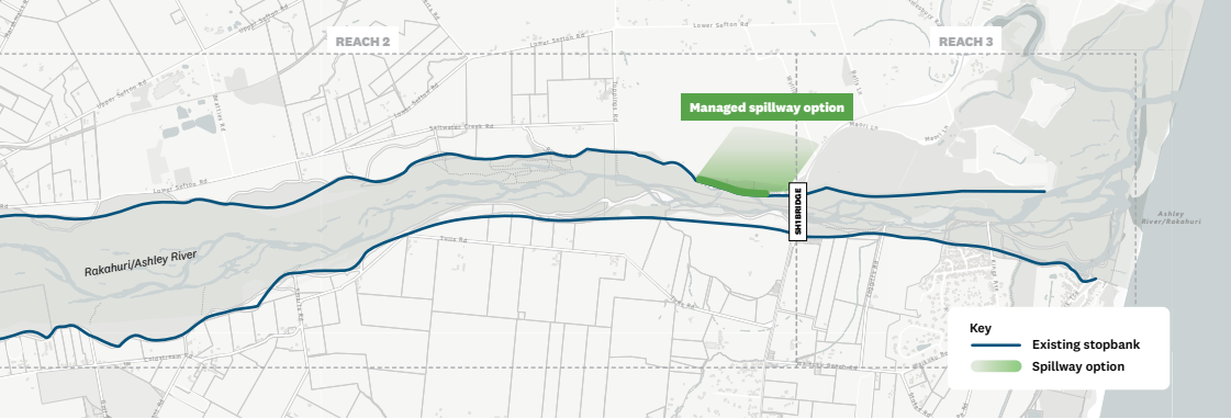
    Option H: Managed spillway. Engineered spillway on north side of the river, upstream of the SH1 bridge
    • Note that the shaded area is indicative only and does not represent exact flows.

    Pros

    • Reduces flood pressure on the SH1 bridge.
    • Improves flood protection for Waikuku.
    • Allows overflows to occur in a controlled and predictable way.
    • Guidebanks can help direct flood flows along a defined path.

    Cons

    • Will result in flooding of properties within the floodway when activated (likely in excess of 3,000 cumecs, almost twice the recorded peak flow in May 2021).
    • Some properties in this area are at risk of flooding under existing conditions.


    Note: You can add comments directly to these options or give your feedback via the give feedback section of the page.

    Please note that comments you make in this section will appear publicly, so please protect your personal privacy and the privacy of others. Do not share personable or confidential information in this section. 

    Please remain polite and respectful of others and their opinions. We may remove content that contains: Racism or hate speech, disrespectful, rude, or abusive language, threats to another person or organisation, including us and our employees, potentially defamatory statements, spam or links to external sites, off-topic information irrelevant to the thread, obscene, offensive, harassing, or discriminatory content toward any person or organisation, including us and our employees.
    Managed spillway: Engineered spillway on north side of the river upstream of the SH1 bridge 

    The State Highway 1 bridge limits how much water can safely pass through this section of the river during flood events.


    If flood capacity is increased, a spillway could be used to allow water to overflow from the river in a controlled manner to the north and into either Saltwater Creek or across the highway and into the estuary.

    Option H: Managed spillway. Engineered spillway on north side of the river, upstream of the SH1 bridge
    • Note that the shaded area is indicative only and does not represent exact flows.

    Pros

    • Reduces flood pressure on the SH1 bridge.
    • Improves flood protection for Waikuku.
    • Allows overflows to occur in a controlled and predictable way.
    • Guidebanks can help direct flood flows along a defined path.

    Cons

    • Will result in flooding of properties within the floodway when activated (likely in excess of 3,000 cumecs, almost twice the recorded peak flow in May 2021).
    • Some properties in this area are at risk of flooding under existing conditions.


    Note: You can add comments directly to these options or give your feedback via the give feedback section of the page.

    Please note that comments you make in this section will appear publicly, so please protect your personal privacy and the privacy of others. Do not share personable or confidential information in this section. 

    Please remain polite and respectful of others and their opinions. We may remove content that contains: Racism or hate speech, disrespectful, rude, or abusive language, threats to another person or organisation, including us and our employees, potentially defamatory statements, spam or links to external sites, off-topic information irrelevant to the thread, obscene, offensive, harassing, or discriminatory content toward any person or organisation, including us and our employees.

    You can use @ to tag somebody in the conversation

    Reply notification settings
    Email
    loader image
    Didn't receive confirmation?
    Seems like you are already registered, please provide the password. Forgot your password? Create a new one now.
    Submitting your comment
    Cancel