
Ashley Rakahuri flood resilience project
Over the next several years, we’re planning to create new flood resilience measures along the 22km section of the Ashley Rakahuri that runs between the Ōkūkū River and Waikuku Beach.
Our goal is to strengthen flood resilience for Rangiora, Kaiapoi, Waikuku, and surrounding areas.
The feedback survey closed on 31 August 2026. You can still add comments in the design options section, ask questions in the questions and answers section, or email us at rivers.delivery@ecan.govt.nz
Feedback received by 5pm on Wednesday 30 September 2026 will also be considered as part of the options analysis process.
There will be further opportunities to have your say as the project progresses.
Why we’re doing this work now
Early flood protection works on the Ashley Rakahuri started in the 1930s. The existing stopbank scheme has protected the district for around 70 years, but over that time, the flood risk has increased.
- Recent events, such as the Kaikōura floods, Auckland Anniversary floods and Cyclone Gabrielle, have demonstrated that extreme rainfall and flooding are happening more often and causing greater damage than in the past. Scientific evidence shows these types of events are becoming more frequent and intense.
- There are now more people, homes, businesses and infrastructure located within the Ashley Rakahuri floodplains. This means the consequences of flooding are higher than they were when the scheme was first built. View our flood modelling maps to see the areas that could be affected during a 1‑in‑500‑year flood event.
- Our modelling shows there is a risk of floods breaking out at different points along the river. We want to ensure our flood protection reflects today’s risks and that they are fit for the future.
Our approach
As we follow the Ashley Rakahuri from its confluence with the Ōkūkū River to the coast, the river changes. Flood breakouts can travel in different directions and have different impacts in different places. That's why we're looking at the river in three reaches, each requiring different ways to manage breakout flooding risk.
Reaches:
Reach 1: Ōkūkū confluence → Rangiora Railway Bridge
Reach 2: Railway Bridge → SH1 Bridge
Reach 3: SH1 → the ocean
What options we're considering
We’re considering a range of possible solutions that may be combined. Different approaches may be needed for different parts of the river. These include:
- Upgrading or modifying the existing primary stopbank
- One or more secondary stopbanks
- Managed floodways
- Stopbank retreat
- Berm vegetation management
- Wetland creation / room-for-the-river approaches
- Gravel management
At this early, investigative stage of the project, we have no preferred option/s. Your feedback will help select a preferred option by correcting our assumptions and highlighting unintended consequences. This will be balanced with other criteria such as safety, practicality for land use, environmental and cultural outcomes, feasibility and cost.
Have your say on flood resilience options
- View the current design options and add your comments
- You can provide feedback by using the questions and answers section, or emailing rivers.delivery@ecan.govt.nz until 5pm on 31 September 2026.
- Read more information about the project details, timeline and how decisions will be made.
- View flood modelling maps based on a 1-in-500-year flood event
- Sign up for updates: Join the mailing list in the 'Stay Informed' area of this page
-
Estuary options: Modifications to stopbank on north side of the Rakahuri at the estuary.
This option considers modifying the existing stopbank on the north side of the river downstream of SH1.
This might include lowering or removing sections of the existing north-side stopbank to relieve pressure on the south-side stopbank, and to lower flood levels near Waikuku Beach.
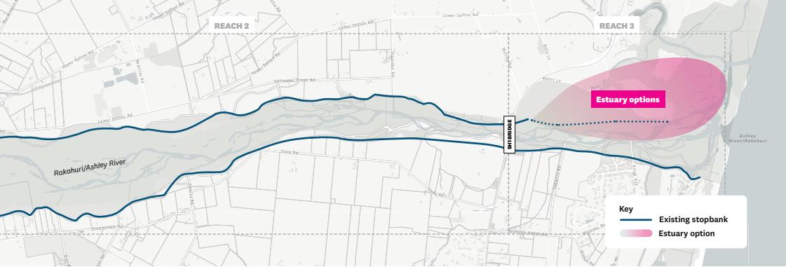 Option I: Estuary options. Modifications to stopbank on north side of the Rakahuri at the estuary
- Note that the shaded area is indicative only.
Pros
- May reduce flood levels near Waikuku Beach.
- Allows for the future effects of sea level rise by retreating flood protection from land that may be inundated.
- Creates opportunities for large-scale estuary restoration.
Cons
- May affect private land and farming activities.
Note: You can add comments directly to these options or give your feedback via the give feedback section of the page.
Please note that comments you make in this section will appear publicly, so please protect your personal privacy and the privacy of others. Do not share personable or confidential information in this section.
Please remain polite and respectful of others and their opinions. We may remove content that contains: Racism or hate speech, disrespectful, rude, or abusive language, threats to another person or organisation, including us and our employees, potentially defamatory statements, spam or links to external sites, off-topic information irrelevant to the thread, obscene, offensive, harassing, or discriminatory content toward any person or organisation, including us and our employees.Go to discussion